
HURRICANE.png
Image

|
Houston Galveston Region Hurricane Preparedness Guide |
Planning is critical to making sure you can evacuate quickly and safely. Your Disaster Preparedness Plan will help guide you and your family’s response and actions during a hurricane, tropical storm, flood, or other natural disaster. The best time to create a plan is before hurricane season, when you have time to plan and consider alternatives. If you wait before a hurricane arrives, you will be rushing to prepare your family as well as your home.
Build a Disaster Preparedness Kit
Fort Bend County is a pass-through county for Coastal County Evacuations. North Side of County State Highway 6, U.S. Highway 59, Hwy 99, and South Side Hwy 36 are designated as Hurricane Coastal Evacuation Routes, additionally, U.S. Highway 90A.
Pass-through county” refers to a county where coastal residents from neighboring counties travel through during evacuations. Fort Bend County could still be an impacted county, so coastal evacuees are directed to use the routes to pass through the county. These residents are moving away from the coast to safer areas. Fort Bend County in Texas serves as a pass-through county for evacuations. During evacuations, intersections may be blocked, and traffic lights set to facilitate movement away from the coast. During an evacuation, coastal residents from Galveston and Brazoria Counties will travel through Fort Bend County. Local residents are urged to avoid these roadways during a period of evacuation. Many intersections will be blocked and lights will be set to allow traffic to move away from the coast. The Texas Department of Transportation will “contra-flow” many highways to handle the increase in traffic moving inland. The state plan also calls for additional fuel, water, and food to be available along evacuation routes.
The term “RUN FROM THE WATER, HIDE FROM THE WIND” describes the simple actions to protect families from the effects of a hurricane, including high winds, storm surge, heavy rains, and tornadoes. Areas close to the Gulf Coast are categorized as evacuation zones. Fort Bend County area is not subject to the effects of storm surge and is not included in a coastal evacuation zone. However, the threatened landfall of a Category 4 or 5 Hurricane may result in the need to evacuate Fort Bend County. The Fort Bend County Homeland Security Emergency Management Team emphasizes that residents have a local evacuation plan. This is a reminder that the hurricane category only indicates the wind level. It does not consider tidal surges, rainfall, flooding, and other hazards. Fort Bend County has the potential for flooding and would require officials to direct evacuations. If directed to evacuate, residents should have a plan to evacuate with multiple routes around evacuation routes to get to higher ground or a safe location. Messaging will be presented on multiple forums, websites, social media, and AM Radio for shelters and hazardous areas (flooded roads) to avoid.
Many individuals may not have access to vehicles or transportation to evacuate. Persons who need special assistance to evacuate should register with the State Texas Emergency Assistance Registry STEAR dial 2-1-1, https://stear.tdem.texas.gov/Login.aspx
or contact Fort Bend County Health and Human Services 281-342-3411 to participate in the Special Needs Registration process. Few buildings in the area are designed to withstand the winds associated with a category 4 or 5 Hurricane. Should an evacuation be called for Fort Bend County, residents should move inland or west. The location of shelters will be announced in the media, with certain zones directed to specific inland shelters and special needs resident assistance as available.
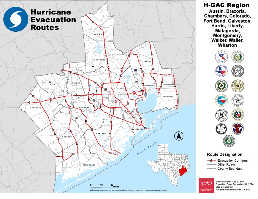
COASTAL COUNTY EVACUATION MAP

FORT BEND COUNTY COASTAL EVACUATION MAP